Trails
Whaley Bridge to Windgather Rocks Walk
This beautiful 6.6 mile walk takes you out of the historic town of Whaley Bridge to the mighty gritstone crag of Windgather Rocks (416m), offering spectacular views over the surrounding countryside.
About
This beautiful 6.6 mile (10.6km) walk takes you out of the historic town of Whaley Bridge on quiet roads to the pretty village of Taxal, before following field paths and forest tracks to the mighty gritstone crag of Windgather Rocks (416m), offering spectacular views over the surrounding countryside. It returns on quiet country lanes and field paths via Taxal Moor before heading back to the centre of the town past a wide range of independent shops, cafés, pubs and restaurants. There are gates and stiles on this route and the terrain is rocky and uneven in places.
Start point: Canal Wharf Car Park, Tom Brads Croft, Whaley Bridge, High Peak SK23 7LX /// popped.scanty.rapport
Alternatively arrive by train, Whaley Bridge rail station is served by regular Northern services from Sheffield and Manchester.
Respect, Protect, Enjoy Whether you're a regular or brand new visitor, we want to make your trip to the Peak District & Derbyshire as safe, easy and enjoyable as possible. Ensure your visit is a responsible one by following the Countryside Code and stay #PeakDistrictProud by keeping dogs on a short lead, parking only in designated areas, sticking to public rights of way where you can, saying no to BBQs and open fires, and taking your litter home with you.
Written and produced exclusively for Visit Peak District & Derbyshire by Peaklass. Find out more at peaklass.com
Trail directions
Begin your walk at the Canal Wharf Car Park in the centre of Whaley Bridge. Walk out of the car park and turn left, continuing straight on via a footpath to the iron bridge across the River Goyt. Look out for the narrow lines of the old Cromford and High Peak Railway still visible on the bridge.
Immediately after crossing the bridge turn right on the footpath and walk up Bridge Street past The Goyt Inn on your right. At the T-junction ahead turn left and then almost immediately right, crossing the main road with care, and walk along Reservoir Road, to the side of The Railway pub. Walk under the railway bridge and, where the road bears right, turn left into the no-through road.
After approx 200 metres, take the footpath on the left signposted to Memorial Park. Stay on the main path through this pretty park, passing the war memorial on your right, and then head out through the park gates onto Goyt Road. Walk along Goyt Road to the T-junction and turn right onto Lower Macclesfield Road. Follow this quiet residential street for approx 500 metres and then turn left into Linglongs Road.
After passing a new housing estate on your left you will soon be out into open countryside, following this peaceful lane through fields. After approx 750 metres you’ll reach the pretty village of Taxal, passing the historic Taxal Church on your left, dating back to the 12th Century.
Stay straight on the lane (now Whiteleas Road) as you leave the village of Taxal, ignoring footpaths off. If you have time, look out for a path on your left approx 300 metres after leaving Taxal, which takes you down into the pretty oak woodland of Hillbridge and Park Wood Nature Reserve. Retrace your steps back to Whiteleas Road to continue the walk.
After approx 800 metres you will pass Overton Hall Farm on your right and then come to a T-junction of lanes. Turn right and follow the lane gently uphill through fields.
After approx 400 metres you will reach a T-junction with Taxal Moor Road. Cross straight on over the road and take the clearly signed public footpath that heads uphill over the fields and out onto Taxal Moor. Continue straight on as the path crests a hill, looking down over a wooded valley ahead.
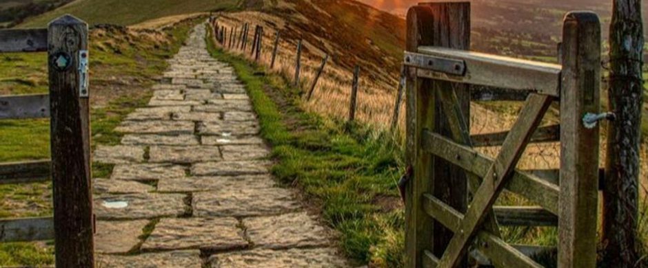
Keep going roughly straight on, passing the iconic green footpath signpost, and head downhill following the sign towards Windgather Rocks, through a wooden gate at the far end of a stone wall. Follow the path with the stone wall to your right as it leads into Goyt Forest.
As you enter the trees, follow the clearly marked path that bears left downhill and over a wooden footbridge, before rising gently again to the edge of the forest at the top of the hill. When you reach a stone wall at the top of the trees, turn left through a small wooden gate and follow the path with trees to your left and the wall to your right.
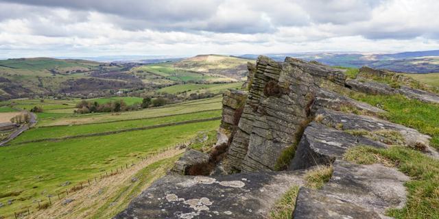
At the end of the wall follow the path as it bears right. Go straight on through a wooden gate as you near the top of the hill and walk straight on to reach the spectacular gritstone crag of Windgather Rocks. Rest awhile to enjoy the magnificent views!
To continue the walk, turn left and walk in a southerly direction, keeping the edge on your right. After approx 250 metres look out for a path down on your right that leads beneath the rocks and out through a gate onto Side End Lane. There are beautiful views in all directions.
Turn right on the lane and follow it for approx 800 metres until you reach a crossroads. Turn right onto Clayholes Road. Ignore all footpaths and tracks off and follow the lane as it bears left. After approx 700 metres you’ll pass Needhams Farm on your right. Very soon afterwards, take the footpath on your right, crossing a step stile over a stone wall.
Head straight on over the grassy field, walking gently uphill and keeping to the right of a now largely flattened stone wall. When you reach the stone wall at the far edge of the field, continue straight on over the rather steep ladder stile.
Go straight ahead after crossing the ladder stile, walking over Taxal Moor with beautiful views ahead. At a junction of paths with a prominent signpost, bear left and follow the path downhill through trees signposted to Taxal. After approx 300 metres the path reaches Taxal Moor Road.
Turn left and follow this quiet lane with beautiful views ahead. After approx 500 metres you’ll see an unnamed lane heading off to the left. Ignore this lane and keep following Taxal Moor Road, but very soon after, as Taxal Moor Road bears right, take a narrow footpath straight on through a gap in a stone wall. This pretty path takes you into the beech woodland of Taxal Beeches.
Keep following the path through Taxal Beeches for approx 150 metres. The path eventually becomes a narrow metalled road and leads down past houses to reach Macclesfield Road. Turn right at the T-junction at Macclesfield Road, returning to Whaley Bridge.
Follow Macclesfield Road for approx 1.5km, passing Linglongs Road (now on your right) and Goyt Road (now on your left) that you took earlier in the walk. Stay on Macclesfield Road until you reach a set of traffic lights at a crossroads, and turn left onto Buxton Road. You will pass a number of independent shops, pubs and cafes on the way if you need refreshments after your walk.
Continue straight on Buxton Road for approx 800 metres, until you reach the train station on your left. Turn right opposite the station, crossing the road with care, and return to Bridge Street that you walked up at the start of the walk. Retrace your steps, turning left at the bottom of Bridge Street and over the iron bridge across the River Goyt, returning to the car park on your right.
Sign up to our newsletter
Receive the latest news, special offers, ideas and inspiration straight to your inbox by signing up to the Visit Peak District & Derbyshire e-newsletter.